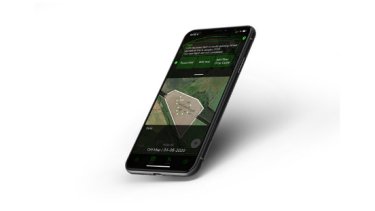
A crop scouting mobile app is the first to automate drones using maps from almost any source. Drone Ag has revealed FieldMap Imports, an addition to its Skippy Scout app, that offers farmers the opportunity to import any map. “This technology means that farmers can now use digital and printed maps to guide automated crop scouting with a drone,” explains Drone Ag founder Jack Wrangham.
The unique functionality has been designed to help save time crop walking by using drones. “If a farmer has a map of a field they want to walk and can photograph it or upload it on to their phone, Skippy can interpret the map. This means any map can be used to take leaf level images of a crop with just a drone and a phone,” says Mr Wrangham.
Using existing satellite, digital and printed maps, users can choose which fields to monitor and the app also has the functionality to store fields to be repeatedly monitored. “We have even tested it with old printed water main maps, and it worked perfectly. The points can also be saved for the user and their agronomist to review crop health throughout a season by comparing maps and yields year on year,” says Mr Wrangham.
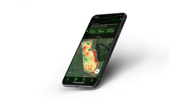
No other drone-based crop scouting system has the functionality to use maps in this way. Mr Wrangham believes that it is the key to unlocking drone technology for those uneasy with technology. “You don’t need a license to use drones under 250 grams and the farmer doesn’t have to fly the drone. Skippy will automatically convert any map so the user can choose points for the drone to fly to. The drone flies to the points and sends images back to the phone for the farmer to view,” he explains.
Skippy Scout is a monthly subscription starting at £30 per month for a single user. “Drones, suitable for crop scouting, start at £369 for a Mavic Mini which means that a farmer can use Skippy and a drone for less than £800 a year,” says Mr Wrangham.
This feature is the first update to the app which was launched in March. “We plan to keep developing Skippy this year and in to 2021. We are finalising an automatic image analysis feature that will offer GAI, weed coverage percentage and unhealthy leaf percentage,” says Mr Wrangham.